Having just started birding about 3 years ago, many of the natural history (and geography) aspects of Essex County were not really on the top of my mind. Of course, I knew that Agriculture was all around, and was a major part of Essex County's economy but did not think about it much more than that. This blog posting attempts to share some insight that I have recently gained on the topic of the following fact: Southwestern Ontario has destroyed almost all of its wetlands. More specifically, this posting is a long-winded reflection on a book I read in March this year called "Mans Impact on Point Pelee National Park" and attempts to summarize parts of Ch 7 & 8 of the book.
“The Onion Fields?”
For me, reading Tom Hince’s Book “A Birders Guide to Point Pelee” was the first mention to the “Onion Fields” of Point Pelee that I had heard about. He didn’t get into detail but mentions that thousands of acres of marshland between Point Pelee and Hillman Marsh were “Reclaimed” (Interesting Perspective). From that point, I had to find out about these Onion Fields, that is, just to see them and find them. Google Maps makes it easy to study the geography of any location, so I made a point (no pun intended) of getting out to the onion fields and seeing them for myself. After driving between Hillman Marsh and Point Pelee, and driving on roads 19 and Mersea Dd D (aka North Dyke Road) I was left with one impression: I can’t believe how Black, how rich the soil looks.

More Insight, but Not Much More…
As I discovered more about Point Pelee National Park, I would make an attempt to walk more of its trails and really discover the park. I think Delaurier Homestead Trail was a late discovery as I got to know the park, and I realized it is good both in terms of the history or the park and its great for birding as well. One trail-side sign really caught my attention near the “octagon platform” on an elevated boardwalk on Delaurier Trail. It was an old newspaper article, possibly dating from the 1890’s (or 1950’s) which gave the town some insight on how the wetlands were being reclaimed, and may have even included an old photo of a steam-shovel that was used to create the ditches and dykes. At the time, I just thought it was incredibly interesting to know about that historical aspect of the park. And it put into motion my interest in finding out more information on the topic.
Many great books have been written about Point Pelee, one or two books by Henrietta O’Neil (“In Search of Heart” & “Birding Point Pelee”) both have generous information about PPNP’s history, but do not really delve into details of Onion Fields and how they were created. In particular, “Birding Point Pelee” was a good read, but my take on it was more about the social history, and the debate about the true direction the park should take. In short, good books, but they did not give much detail on what I was looking to find.
Point Pelee's website itself has some good general information on the general history of the park, aside from the creation of the Onion Fields is interesting as well. In a nutshell, you have Native Americans that habited Point Pelee, then British Military, then European Immigrants who used the land for Fishing, Farming, Orchards, Tourism and Cottaging. More about this general history can be found at: http://www.pc.gc.ca/pn-np/on/pelee/natcul/natcul2.aspx (Point Pelee NP Website)
Sarah Rupert, who is the PPNP Interpreter suggested that I look at a book entitled: Man’s Impact on Point Pelee National Park University of Windsor
“This book reveals that the present Point Pelee Landscape is quite different than any of the other changing states through which it passed in the last several centuries…. Since that time, Point Pelee has been subjected to commercial trapping, fishing, lumbering, mining, drainage, cultivation, grazing and other cultural processes. The current and future state of the park ecosystem can only be understood in terms of these processes” (Battin & Nelson).
Finally, some real information and insight that I've been looking for!!! This is where this summary gets interesting. The image below shows what Point Pelee looked like in the 1890's. Point Pelee's Marsh basically extended all the way to Hillman Marsh!
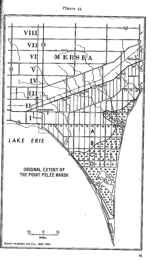
According to Nelson & Battin, on November 20, 1893, W.L. Scott presented Mersea Town Council a petition signed by RL Hillman and 37 others that the swamps between Hillman Marsh and Point Pelee be reclaimed by dyking to bring such land into a state of usefulness.

Interesting how they frame what must have been a breathtaking example of great lakes marsh: "Ten thousand acres of have for ages lain entirely useless, serving no better purpose than as the home of muskrats and wildfowl" . The book goes on to state that: "Agriculture quickly put this land into use when this incredibly rich, peaty soil to produce crops such as wheat, barley, corn & potatoes like they’ve never seen before". Who was this WL Scott that presented a signed petition with 30 or so signatures? I'm dying to know who the interests were that started this project. No matter how hard I look, the details are vague.
 |
| Notice to the left of "Row B" you have Sturgeon Creek and the right side of "Row A" is Hillman Marsh. The bottom or Row D is the "North Dyke Road" or Concession D. The marsh of Point Pelee remained intact south of Concession D, even though in 1914, interests had petitioned to turn all of the remaining marshes into farmland. The audacity! |
 |
| This photo shows what Steam shovels would have looked like in the early 1900's. This is an Erie B modified for trenchwork. I tried finding a specific photo from this Pelee but came up short. Source:(Berry) |
Costs of this Project: Who Paid? Who Profited?
While reading though Chapter 7, it was noteworthy to consider how expensive it was to dyke these fields. As I had read paragraph after paragraph, it dawned on me that this was not a one-time deal. This project had ongoing costs and engineering challenges that were extremely expensive.
1895: $22,844.00
1903: $13,721.00 & 4,000
1905: $46,000 & $8,900
1908: $26,000
1909: $9,596.00
1910: $14,490
1914: (Further drainage to Concession D by private landowners 535 Acres)
1922: Poor conditions prompted Concession D landowners to “Petition Mersea township to take over responsibility”.
1903: $13,721.00 & 4,000
1905: $46,000 & $8,900
1908: $26,000
1909: $9,596.00
1910: $14,490
1914: (Further drainage to Concession D by private landowners 535 Acres)
1922: Poor conditions prompted Concession D landowners to “Petition Mersea township to take over responsibility”.
The authors of this book conclude chapter seven by stating that nobody seems to have done a cost-benefit analysis but if one did, it would have had to include the intangibles such as destruction of wetlands and habitat to wildlife, not to mention the huge eco-tourism benefits this gorgeous wetland could have provided to future generations. Essentially, this “Halving” of Point Pelee has stressed the remaining wetlands which are required to serve both as a recreational and conservation spot not to mention wildlife habitat. Mersea Township Residents and Ontario
A Request to Reclaim All of the Marshland, South of Concession D to Shuster Trail
A Request to Reclaim All of the Marshland, South of Concession D to Shuster Trail
Chapter 8 continues on about the park after it was transformed. To my amazement the book states that in 1914, the Point Improvement Company applied to drain the remaining 2685 acres of wetlands for cultivation! This request was declined by the Ordinance and Admiralty Lands Department by stating on the grounds that “…tracts of land or marsh suitable for the propagation and preservation of game where the public may enjoy a few years sport are very scarce and becoming more so each year. The land should be retained as a game preserve for the public interest”. Imagine this department did not push back a little on this interestingly named company "Point Improvement Company"... There would not be any marshes to go kayaking. It would have all been destroyed.
Sand Dredging
The book states that in 1914, American Operators dredged or sucked sand from the submerged deposits off the southern tip of the peninsula. This prompted C.E. Kingsmill , vice admiral and director of naval services to state:

Did this major industrial removal of sand below the waters surface change the hydro-dynamics of the park? This may have triggered the present day erosion problems that Point Pelee is facing, with severe erosion along both the east and west beaches as well as the tip. The tip trees, flotation device posts, and park benches are literally being washed away into Lake Erie . (In speaking to various people on the topic of shoreline erosion at Pelee, it seems that hardened shorelines with metal breakwalls has disrupted the natural process of erosion and deposition).
Chapter 8 also discusses the effects of private land owners, cottaging, hunters shooting lead bullets and using motorized boats which surely spilt oil and fuel into the marsh, Cattle and Hog grazing, tourism and campers trampling on flora and fauna… Companies would even go through and remove all the dead trees for firewood. (They obviously did not understand the importance of snags) Groups petitioned the parks in the 1930’s to remove the underbrush and thickets to beautify the park and give it a “neat appearance”.
Changing Directions and deciding on the future of the park
By 1939, government officials expressed strong concern about the deteriorating conditions of the park. Tanner stated best the decision park managers had to make about the park considering all the stresses people were putting on the park.
“Point Pelee National park
I think this preceding quote eloquently expresses the tradeoff the park faced in the 1930's. There is much more to the story but basically, many businesses and cottages were expropriated from the park and their footprints have slowly been erased by successional grass, scrub and forest regeneration.
Closing thoughts
Its funny how birding has led me to learn so much more than just about birds. In this case, these beautiful avian creatures have led me on a path of slowly trying to understand what has happened to the landscape of Southwestern Ontario. Like I mentioned in the introduction of this blog entry, I did not even know what Onion Fields were, and slowly, after talking with various people and reading various resources, small bits of our historical and geographical realities come together to form a sobering reality. There is almost nothing left for our present generation of nature lovers to enjoy. Its a sad warning about human behavior and basic economics. If each acre of unfarmed land is simply looked at from the opportunity costs not realized, we have a problem. How can we expect people and corporate interests in Central or South America, who host the most biodiversity per unit of surface area to not follow suit? As we speak, the forests of Borneo and Brazil are being gobbled up by legal and many times illegal deforestation and logging practices. What about Canada's Boreal Forests?Even my recent trip to Carden Alvar brought up many interesting questions. Why must I drive several (5) hours to see an example of habitat that was common in southern Ontario 75 years ago? Why is the nearest Acadian Flycatcher habitat 1.5 hour drive north of Windsor? Why do concerned citizens have to pony up their money to protect integrity of our ecosystem to protect it for future generations? Canada's present population is only 30 million people. If our population doubles to 60 or 100 million people, would the stresses overwhelm what's left of our natural habitat?
Other Southwestern Ontario "Onion Fields"

McGeachy Pond on the southern end of Rondeau Bay. Note the two triangles I have drawn in the google map above. Its funny to think, but most people don't realize that Onion Fields used to be swamps and marshland, but various interests went ahead and converted those wetlands into fertile farming fields. The land outside of the two red triangles above have all been dyked and drained to create more onion fields. The trailhead sign at Erieau Marsh Trail below mentions this, in a subtle manner.
 |
| Erieau Marsh Trail sign hints of a similar fate of the local swampland. You can read between the lines when it says "In 1915 the Burke Drainage Scheme was installed along the tracks. It drained the fertile farmlands to the north of the trail but unfortunately destroyed much of the wetlands". The Dyke and rail lines were installed in 1889 - 120 Years Ago. |
 |
| Looking north from the Erieau Marsh Trail. Incredibly black rich soil... Must have been an incredible swamp! |
St Clair NWA
The shoreline along Lake St Clair, just north of Windsor/Detroit has been similar fates. Only the smallest remnants of land have survived our insatiable appetite for agriculture, cottaging and residential projects.


Good birding,
Dwaynejava
Point Pelee Onion Fields
http://maps.google.ca/maps?q=41.987439,-82.513704&hl=en&num=1&t=h&z=13
Rondeau Onion Fields
http://maps.google.ca/maps?q=rondeau&hl=en&ll=42.267782,-81.936035&spn=0.019468,0.045447&oe=utf-8&client=firefox-a&hq=rondeau&radius=15000&t=h&z=15
St Clair NWA
http://maps.google.ca/maps?q=42.371481,-82.395086&hl=en&num=1&t=h&z=13
Related Reading:
Listing of all the remaining wetlands in the great lakes system (Just browse through it!)
http://wirenet.mcmaster.ca/publications/papyrus/SOLEC_ecoreaches.pdf
Some more insight on St Clair NWA
http://www.carolinian.org/CarolinianSites_StClairMarshes.htm
http://www.bsc-eoc.org/iba/site.jsp?siteID=ON012
http://www.lambtonwildlife.com/publications/Lambton%20County%20Nature%20Guide.pdf
http://www.sydenhamfieldnaturalists.ca/index.php/resources/natural-areas
http://www.cktimes.ca/article/3347.html
http://www.cktimes.ca/archives/column/7/2990.html
http://www.cktimes.ca/archives/column/7/3029.html
http://www.cktimes.ca/archives/column/7/12381.html
http://www.cktimes.ca/archives/column/7/4439.html
http://www.cktimes.ca/archives/section/7.html
Holland Marsh [google map]
Tom Hince, "A Birders Guide to Point Pelee (and surrounding areas)”, 1999, Print, link
http://www.pc.gc.ca/pn-np/on/pelee/natcul/natcul2.aspx
Battin, J. G., Nelson, James Gordon. "Man's impact on Point Pelee National Park" , Toronto : National and Provincial Parks Association of Canada, 1978. Print.
Steamshovel Photo "Trench shovels dig the foundation for 19th century infrastructure ", http://www.oemoffhighway.com/article/10705600/trench-shovels-dig-the-foundation-for-19th-century-infrastructure
Battin, J. G., Nelson, James Gordon. "Man's impact on Point Pelee National Park" , Toronto : National and Provincial Parks Association of Canada, 1978. Print.
Steamshovel Photo "Trench shovels dig the foundation for 19th century infrastructure ", http://www.oemoffhighway.com/article/10705600/trench-shovels-dig-the-foundation-for-19th-century-infrastructure